
Rich in culture and bound up with Thang Long legends, the Red River is a popular destination for visitors and home to tens of thousands of residents.
Hanoi today embodies both the potential and the strength needed to realize its aspirations and achieve its goal of transforming the areas along the Red River into a new symbol of the capital's development.
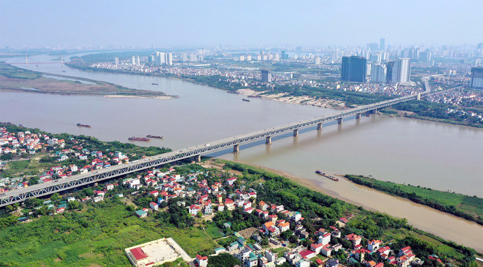 |
| Red River plays a key role in Hanoi's future development. Photo: Hai Linh/The Hanoi Times |
Dr. Dao Ngoc Nghiem, Vice Chairman of the Vietnam Association for Urban Planning and Development, noted that few rivers in the capital have garnered as much attention from scientists, researchers, and architects as the Red River.
After the complete liberation of the capital in October 1954, the first study on the Red River was carried out in 1962. However, the most significant milestone came in March 2022, more than six decades after the initial 1962 study, when the historic "Red River Urban Zoning Plan Project" was officially approved.
“This project is crucial as it defined the architectural landscape of Hanoi, establishing the Red River's space as the central landscape axis of the city, linked to the West Lake-Co Loa axis, and forming a focal point in the city's spatial layout,” said Nghiem.
According to Nghiem, the Red River, with its current status as a culturally rich area, is steeped in the legends of Thang Long, and is a popular destination for both domestic and international visitors.
“It is high time for the Red River to emerge as a new symbol of Hanoi's development,” said Nghiem.
To realize this goal, Nghiem stressed the fact that the Red River benefits not only from its great potential and advantages but also from considerable attention at both central and city levels. This includes directives and orientations from Politburo in Resolution No. 15-NQ/TW dated May 5, 2022, and Conclusion No. 80-KL/TW dated May 24, 2024, emphasizing the need for Hanoi to focus on developing the Red River corridor.
The aim is to make the Red River a true center of the capital's development, with a harmonious distribution of ecological, cultural, historical, green, and modern urban spaces on both sides, contributing to a new image of a civilized, modern, and culturally rich capital.
Additionally, the Capital Law 2024, recently passed by the 15th National Assembly, emphasizes prioritizing resources and implementing the Red River Zoning Plan in line with Hanoi's overall planning for 2021-2030, with a vision to 2050, and the general adjustment project of Hanoi's master plan to 2045, with a vision to 2065.
Specifically, the Capital Law 2024 allows for the development of a cultural industry center on the Red River's riparian areas and sandbanks and permits the use of agricultural land in the areas outside the dyke for agricultural production, eco-agriculture, and agriculture combined with tourism and educational experiences, Nghiem said.
He noted that this must be done in accordance with flood prevention plans, dike planning, construction planning, and other relevant regulations.
Nghiem also pointed out that the Capital Law 2024 grants the Hanoi People's Council the authority to issue specific regulations and gives the Hanoi People's Committee the power to approve construction on the riverbanks. These new regulations provide a favorable legal framework to ensure both effective disaster prevention and efficient use of riverbank land in Hanoi, he said.
 |
| The North of the Red River includes districts of Me Linh, Long Bien, Dong Anh. Photo: Trung Nguyen/The Hanoi Times |
Nguyen Mai Vy, a resident of Nhat Tan Ward, Tay Ho District, said she often explores the sandbanks and Red River Stone Beach with her family and friends. Through these trips, it is evident that the islet area, with its vast natural green space, has significant potential for development. However, access to the sandbank is not easy, as it requires private vehicles to cross the Long Bien Bridge and then navigate narrow paths to reach the destination.
"Due to the demand for space and recreation, not only my family and friends but also hundreds of visitors come to the alluvial islet, the Red River Stone Beach, and other areas every day to experience the wild beauty of these places. So when I heard that the city and districts like Hoan Kiem, Ba Dinh, Tay Ho, and Long Bien were planning to turn the Red River's banks into a multifunctional cultural eco-park, I'm sure it garnered a lot of support, especially from those who are passionate about exploring and experiencing nature," said Vy.
Nguyen Mai Huong from Ngoc Thuy Ward, Long Bien District, also noted existing issues, such as residents encroaching on the alluvial islet, causing disorder and clutter. Therefore, implementing a systematic and well-planned approach to developing this area is essential.
“This will help state agencies manage and use the alluvial islet’s land resources more effectively for the benefit of the community,” Huong said.
Residents and experts also emphasize that any planning, especially for large-scale projects, should respect and preserve the unique natural beauty of the area.
“It is important to avoid excessive urbanization to protect the ecosystem, adapt the landscape to the Red River's hydrology, and optimize the natural environment for future development,” said Huong.
“The Hanoi People's Committee has instructed the four districts of Hoan Kiem, Ba Dinh, Tay Ho, and Long Bien to intensify research efforts to fully capitalize on the potential of the Red River, aiming to transform it into a new symbol of the capital's development. To take this initiative forward, the four districts have jointly launched a competition to design ideas for a multifunctional cultural park on the sandbanks of the Red River. So far, many individuals and organizations have enthusiastically participated in the competition. The resulting submissions will provide valuable resources for the districts to draw upon and help formulate detailed plans that will progressively realize the goal of making the Red River a true symbol of Hanoi’s future growth,” Nguyen Toan Thang, Head of the Urban Management Department at Hoan Kiem District said. |